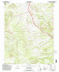
1995 Map of East Gavilan Canyon
USGS Topo · Published 1998About this map
The Tierra Amarilla Grant dominates this high-altitude landscape of northern New Mexico, where traditional land use patterns meet federal management at the National Forest Boundary. The presence of Peterson Cow Camp, Crowther Cow Camp, and Johnson Cow Camp reflects the area's legacy of seasonal grazing and livestock movement across the high country. These camps, often located near water sources like Spring and Gavilan Tank, are connected by a network of unimproved 4WD roads that navigate the complex drainage systems of Rio Vallecitos and Rio Nutrias.
Find a feature on this map
40 named features on this map. Tap any name to fly to it.
Don’t see what you’re looking for? This feature index may not catch every label — zoom into the map to look around manually.
Map Details
Editions of this 1995 East Gavilan Canyon Map
This is the sole edition of this map. No revisions or reprints were ever made.
Other maps of this area

1918 · Tusas
USGS Topo · 1:125,000

1954 · Aztec
USGS Topo · 1:250,000

1955 · Cebolla
USGS Topo · 1:62,500

1955 · Brazos Peak
USGS Topo · 1:62,500

1958 · Aztec
USGS Topo · 1:250,000

1962 · Aztec
USGS Topo · 1:250,000

1963 · Broke Off Mountain
USGS Topo · 1:24,000

1963 · Burned Mountain
USGS Topo · 1:24,000
1963 · Canon Plaza
USGS Topo · 1:24,000

1965 · Aztec
USGS Topo · 1:250,000