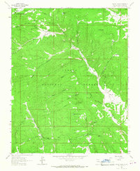
1963 Map of Canon Plaza
USGS Topo · Published 1967About this map
Carson National Forest dominates this section of Rio Arriba County, where the high-altitude landscape is carved by deep canyons and seasonal drainages. The small settlement of Cañon Plaza sits at the confluence of the Rio Vallecitos and Cañada Alamosa, serving as a focal point for the surrounding ranching and forestry activities. This 1963 field-checked survey reveals a complex network of water management features essential for livestock in the high desert, including the Jacques Canyon Tank No 1, Burro Tanks, and La Jara Canyon Tank. Evidence of early land management is seen in the northern border with the Tierra Amarilla Grant. The map also captures local recreational sites such as the El Ritito Campground and various family-named landmarks like Jaramillo Ranch, illustrating the intersection of public land use and private heritage in northern New Mexico.
Find a feature on this map
43 named features on this map. Tap any name to fly to it.
Don’t see what you’re looking for? This feature index may not catch every label — zoom into the map to look around manually.
Map Details
Editions of this 1963 Canon Plaza Map
2 editions found
Other maps of this area

1918 · Abiquiu
USGS Topo · 1:125,000

1918 · Tusas
USGS Topo · 1:125,000

1953 · Valle Grande Peak
USGS Topo · 1:24,000

1953 · Magote Peak
USGS Topo · 1:24,000

1953 · La Madera
USGS Topo · 1:24,000

1954 · Aztec
USGS Topo · 1:250,000

1955 · Cebolla
USGS Topo · 1:62,500

1958 · Aztec
USGS Topo · 1:250,000

1962 · Aztec
USGS Topo · 1:250,000
1963 · Las Tablas
USGS Topo · 1:24,000