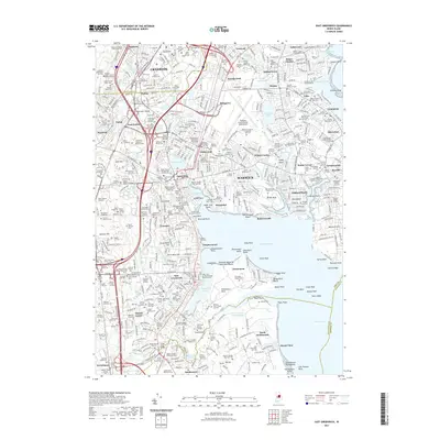
2021 Map of East Greenwich
USGS Topo · Published 2021About this map
Greenwich Bay and the complex shoreline of Warwick define this modern survey, revealing the dense intersection of suburban development and historical land use. The landscape is characterized by its maritime geography, from the sheltered Apponaug Cove to the expansive Goddard Memorial State Park Beach at Potowomut. Inland, the map is remarkably dense with family burial grounds and small plots, such as the Baker Family Slave Cem and the Elder Elisha Greene Lot, providing a granular look at the region's genealogical heritage. These historic sites sit alongside major modern infrastructure, including the Theodore Francis Green State Airport and the Amtrak rail corridor. From the industrial legacy of Pawtuxet Valley to the judicial center at the Noel Judicial Complex, the map details a community where colonial-era landmarks and 21st-century transit hubs coexist.
Find a feature on this map
238 named features on this map. Tap any name to fly to it.
Don’t see what you’re looking for? This feature index may not catch every label — zoom into the map to look around manually.
Map Details
Editions of this 2021 East Greenwich Map
This is the sole edition of this map. No revisions or reprints were ever made.
Other maps of this area

1887 · Providence
USGS Topo · 1:62,500

1889 · Providence
USGS Topo · 1:62,500

1889 · Burrillville
USGS Topo · 1:62,500

1890 · Narragansett Bay
USGS Topo · 1:62,500

1890 · Kent
USGS Topo · 1:62,500

1892 · Narragansett Bay
USGS Topo · 1:62,500

1894 · Burrillville
USGS Topo · 1:62,500

1894 · Kent
USGS Topo · 1:62,500

1894 · Providence
USGS Topo · 1:62,500

1915 · Burrillville
USGS Topo · 1:62,500