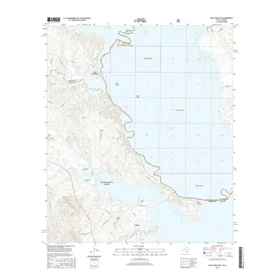
2016 Map of East Hamilton
USGS Topo · Published 2016About this map
Toledo Bend Reservoir dominates the eastern half of this landscape, marking the inundated border between Texas and Louisiana. The terrain west of the water is characterized by the dense woodlands of the Sabine National Forest, where a network of forest roads and small creeks like Patroon Bayou and Bourghs Cr carve through the land. Small communities and family landmarks are concentrated along the western shore, particularly around the settlements of East Hamilton and Milam.
Find a feature on this map
48 named features on this map. Tap any name to fly to it.
Don’t see what you’re looking for? This feature index may not catch every label — zoom into the map to look around manually.
Map Details
Editions of this 2016 East Hamilton Map
This is the sole edition of this map. No revisions or reprints were ever made.
Other maps of this area

1941 · Zwolle
USGS Topo · 1:62,500

1944 · Negreet
USGS Topo · 1:62,500

1944 · Patroon
USGS Topo · 1:62,500

1944 · Zwolle
USGS Topo · 1:62,500

1953 · Alexandria
USGS Topo · 1:250,000

1954 · Negreet
USGS Topo · 1:62,500

1954 · Salter Creek
USGS Topo · 1:24,000

1955 · Alexandria
USGS Topo · 1:250,000

1956 · Patroon
USGS Topo · 1:62,500
1957 · Zwolle
USGS Topo · 1:62,500