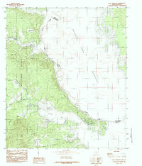
1984 Map of East Hamilton
USGS Topo · Published 1984About this map
Sabine National Forest dominates the western shoreline of the Toledo Bend Reservoir, where the wooded hills of East Texas meet the expansive waters of the state line. This 1984 survey reveals the complex drainage systems that feed into the reservoir, including the winding course of Patroon Bayou and the wide reach of Patroon Bay. The map captures a landscape defined by its transition from timbered upland to the aquatic boundary of the Sabine River, which separates Shelby County from Sabine Parish, Louisiana.
Find a feature on this map
20 named features on this map. Tap any name to fly to it.
Don’t see what you’re looking for? This feature index may not catch every label — zoom into the map to look around manually.
Map Details
Editions of this 1984 East Hamilton Map
This is the sole edition of this map. No revisions or reprints were ever made.
Other maps of this area

1941 · Zwolle
USGS Topo · 1:62,500

1944 · Negreet
USGS Topo · 1:62,500

1944 · Patroon
USGS Topo · 1:62,500

1944 · Zwolle
USGS Topo · 1:62,500

1953 · Alexandria
USGS Topo · 1:250,000

1954 · Negreet
USGS Topo · 1:62,500

1954 · Salter Creek
USGS Topo · 1:24,000

1955 · Alexandria
USGS Topo · 1:250,000

1956 · Patroon
USGS Topo · 1:62,500
1957 · Zwolle
USGS Topo · 1:62,500