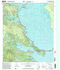
2003 Map of East Hamilton
USGS Topo · Published 2004About this map
The Toledo Bend Reservoir dominates this borderland landscape where the Sabine River separates Shelby County, Texas, from Sabine Parish, Louisiana. Much of the western shore is protected within the Sabine National Forest, preserving a terrain defined by narrow inlets and bayous such as Patroon Bayou and Martinez Bayou. This 2003 revision reflects the established recreational and residential character of the waterfront, contrasting the open water of the reservoir with the densely wooded hills of the national forest.
Find a feature on this map
29 named features on this map. Tap any name to fly to it.
Don’t see what you’re looking for? This feature index may not catch every label — zoom into the map to look around manually.
Map Details
Editions of this 2003 East Hamilton Map
This is the sole edition of this map. No revisions or reprints were ever made.
Other maps of this area

1941 · Zwolle
USGS Topo · 1:62,500

1944 · Negreet
USGS Topo · 1:62,500

1944 · Patroon
USGS Topo · 1:62,500

1944 · Zwolle
USGS Topo · 1:62,500

1953 · Alexandria
USGS Topo · 1:250,000

1954 · Negreet
USGS Topo · 1:62,500

1954 · Salter Creek
USGS Topo · 1:24,000

1955 · Alexandria
USGS Topo · 1:250,000

1956 · Patroon
USGS Topo · 1:62,500
1957 · Zwolle
USGS Topo · 1:62,500