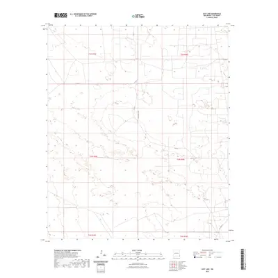
2023 Map of East Lake
USGS Topo · Published 2023About this map
The arid landscape of Lea County, New Mexico, is defined by its grid of range and township boundaries and a sparse network of county roads. The terrain is marked by numerous depressions and closed basins, characteristic of the High Plains geology of the region. Transportation across these sections relies on routes such as Teague Switch Rd and Co Rd 11, which navigate a surface dotted with numerous small, unnamed intermittent water features and natural sinks. The presence of Deep Wells Rd in the southeastern corner suggests the historical and ongoing importance of groundwater access for ranching and industry in this portion of the Permian Basin. This survey captures the region's characteristic isolation and the systematic division of public lands into townships including t23s r36e and t22s r35e.
Find a feature on this map
12 named features on this map. Tap any name to fly to it.
Don’t see what you’re looking for? This feature index may not catch every label — zoom into the map to look around manually.
Map Details
Editions of this 2023 East Lake Map
This is the sole edition of this map. No revisions or reprints were ever made.
Other maps of this area

1954 · Hobbs
USGS Topo · 1:250,000

1958 · Hobbs
USGS Topo · 1:250,000

1963 · Oil Center
USGS Topo · 1:62,500

1969 · Eunice
USGS Topo · 1:24,000

1969 · Jal NW
USGS Topo · 1:24,000

1969 · Rattlesnake Canyon
USGS Topo · 1:24,000

1973 · Custer Mountain
USGS Topo · 1:24,000
1973 · Woodley Flat
USGS Topo · 1:24,000

1978 · Jal
USGS Topo · 1:100,000

1984 · Oil Center
USGS Topo · 1:24,000