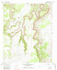
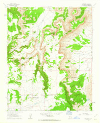
1961 Map of East Mesa
USGS Topo · Published 1984About this map
Laguna Indian Reservation and Acoma Indian Reservation lands converge in this high-desert landscape of the early 1960s, defined by the prominent East Mesa and its network of deeply carved canyons. The map documents a sparse but vital ranching and water infrastructure, featuring named points like Sarracino Ranch on the eastern edge and the Wilson Windmill to the southwest. Land boundaries are complex, including the specific Acoma Purchase tracts that illustrate the historical evolution of tribal land holdings. Natural landmarks such as Needle Pinnacle and Southwest Plaza provide navigation points across a terrain otherwise marked by ephemeral drainages like Big Sandy Wash and Paradise Canyon. A single Jeep Trail provides one of the few established routes through this arid environment, connecting isolated water sources such as Frank Paisano Spring.
Find a feature on this map
19 named features on this map. Tap any name to fly to it.
Don’t see what you’re looking for? This feature index may not catch every label — zoom into the map to look around manually.
Map Details
Editions of this 1961 East Mesa Map
2 editions found
Other maps of this area

1917 · Cerro Verde
USGS Topo · 1:125,000

1917 · Broom Mountain
USGS Topo · 1:125,000

1954 · Socorro
USGS Topo · 1:250,000

1958 · Socorro
USGS Topo · 1:250,000
1960 · South Butte
USGS Topo · 1:24,000
1961 · Acoma Pueblo
USGS Topo · 1:24,000

1961 · Marmon Ranch
USGS Topo · 1:24,000
1961 · Crow Point
USGS Topo · 1:24,000
1961 · East Mesa
USGS Topo · 1:24,000
1961 · Blue Mesa
USGS Topo · 1:24,000