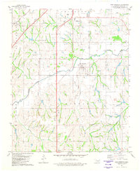
1981 Map of East Ninnekah
USGS Topo · Published 1982About this map
The Little Washita River winds through central Oklahoma, carving a path between the Ninnekah Hills and the Chandler Hills. This landscape is defined by the legacy of early land divisions, clearly marked by the Indian Territory Oklahoma Boundary that persists in the 1980s landscape. Small settlements like Norge and Agawam sit along the periphery, while East Ninnekah serves as a more central hub. The region's mid-century development is visible in infrastructure like the Stidham Landing Strip and the Drive-in Theater, alongside older industrial markers such as scattered Oil Wells. Modern transportation corridors, including the H E Bailey Toll Road and the Burlington Northern railroad, overlay the older river-and-creek drainage system including Rock Creek and Boggy Creek. This survey captures the transition from a purely agricultural and oil-producing territory to one integrated into the state's modern highway network.
Find a feature on this map
24 named features on this map. Tap any name to fly to it.
Don’t see what you’re looking for? This feature index may not catch every label — zoom into the map to look around manually.
Map Details
Editions of this 1981 East Ninnekah Map
This is the sole edition of this map. No revisions or reprints were ever made.
Other maps of this area

1902 · Rush Springs
USGS Topo · 1:125,000

1904 · Chickasha
USGS Topo · 1:125,000

1945 · Anadarko
USGS Topo · 1:62,500

1949 · Cement
USGS Topo · 1:62,500

1949 · Rush Springs
USGS Topo · 1:62,500

1950 · Rush Springs
USGS Topo · 1:62,500

1954 · Oklahoma City
USGS Topo · 1:250,000

1955 · Lawton
USGS Topo · 1:250,000

1955 · Clinton
USGS Topo · 1:250,000

1956 · Laverty
USGS Topo · 1:24,000