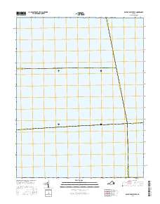
2016 Map of East of Deltaville
USGS Topo · Published 2016About this map
Chesapeake Bay dominates this maritime survey, illustrating the convergence of several Virginia county boundaries at sea. The map documents the aquatic intersection where Lancaster, Accomack, Middlesex, Mathews, and Northampton counties meet. This unique perspective focuses entirely on the open water and the jurisdictional lines that divide the bay, providing a clear record of the modern administrative geography of the Virginia coastline. Without terrestrial landmarks or contours, the map serves as a dedicated study of the bay's political boundaries in the early 21st century.
Find a feature on this map
7 named features on this map. Tap any name to fly to it.
Don’t see what you’re looking for? This feature index may not catch every label — zoom into the map to look around manually.
Map Details
Editions of this 2016 East of Deltaville Map
This is the sole edition of this map. No revisions or reprints were ever made.
Other maps of this area

1916 · Kilmarnock
USGS Topo · 1:48,000

1916 · Mathews
USGS Topo · 1:62,500

1917 · Kilmarnock
USGS Topo · 1:62,500

1917 · Mathews
USGS Topo · 1:62,500

1942 · Kilmarnock
USGS Topo · 1:62,500

1943 · Richmond
USGS Topo · 1:250,000

1948 · Deltaville
USGS Topo · 1:24,000

1948 · Mathews
USGS Topo · 1:24,000
1949 · Fleets Bay
USGS Topo · 1:24,000

1949 · Richmond
USGS Topo · 1:250,000