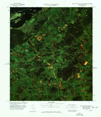
1977 Map of East of Fort Covington Port of Entry
USGS Topo · Published 1978About this map
The international boundary between Canada and the United States cuts directly through this 1970s orthophoto image, showing the closely linked agricultural landscapes of northern New York and southern Quebec. Near the confluence of the Salmon River and the St Lawrence River, the village of Fort Covington serves as a critical point of entry where the Canadian National rail line and local roads like Bunker Hill Road intersect the border.
Find a feature on this map
34 named features on this map. Tap any name to fly to it.
Don’t see what you’re looking for? This feature index may not catch every label — zoom into the map to look around manually.
Map Details
Editions of this 1977 East of Fort Covington Port of Entry Map
This is the sole edition of this map. No revisions or reprints were ever made.
Other maps of this area

1915 · Malone
USGS Topo · 1:62,500

1915 · Moira
USGS Topo · 1:62,500

1917 · Malone
USGS Topo · 1:62,500

1917 · Moira
USGS Topo · 1:62,500

1944 · Moira
USGS Topo · 1:62,500

1948 · Ogdensburg
USGS Topo · 1:250,000

1951 · Ogdensburg
USGS Topo · 1:250,000

1953 · Ogdensburg
USGS Topo · 1:250,000

1961 · Ogdensburg
USGS Topo · 1:250,000
1964 · Ft. Covington
USGS Topo · 1:24,000