
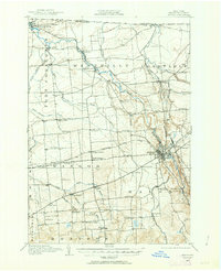
1915 Map of Malone
USGS Topo · Published 1957About this map
The Salmon River and its numerous tributaries dominate this Northern New York landscape, carving through a region defined by agricultural townships and a dense network of early 20th-century railroads. The commercial heart of the area centers on Malone, where the Rutland Railroad and the Adirondack Division of the New York Central and Hudson River RR intersect at Malone Junction. This rail infrastructure served as a lifeline for dispersed rural communities such as Bangor Station and Fort Covington, the latter situated near the international Canada United States border.
Find a feature on this map
55 named features on this map. Tap any name to fly to it.
Don’t see what you’re looking for? This feature index may not catch every label — zoom into the map to look around manually.
Map Details
Editions of this 1915 Malone Map
2 editions found
Other maps of this area

1906 · Loon Lake
USGS Topo · 1:62,500

1908 · Loon Lake
USGS Topo · 1:62,500

1915 · Chateaugay
USGS Topo · 1:62,500

1915 · Moira
USGS Topo · 1:62,500

1917 · Malone
USGS Topo · 1:62,500

1917 · Moira
USGS Topo · 1:62,500

1919 · Nicholville
USGS Topo · 1:62,500

1921 · Nicholville
USGS Topo · 1:62,500

1921 · Santa Clara
USGS Topo · 1:62,500

1923 · Santa Clara
USGS Topo · 1:62,500