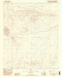
1986 Map of East of Langford Well
USGS Topo · Published 1986About this map
Fort Irwin Military Reservation dominates this high-desert landscape in the mid-1980s, revealing a terrain defined by arid basins and remote ridgelines. The map is centered on a dry basin containing Langford Well Lake, a seasonal feature typical of the Mojave's interior drainage patterns. This provisional edition, compiled from early 1980s aerial photography, documents a network of primitive transportation routes, specifically marked as 4wd tracks, which navigate the complex topography between the military boundary and the surrounding hills. The transition between township lines t13n t12n and the Mil Res Bdy highlights the jurisdictional management of this protected desert region, providing a baseline for researchers tracking land use and access within the San Bernardino County desert during the late twentieth century.
Find a feature on this map
5 named features on this map. Tap any name to fly to it.
Don’t see what you’re looking for? This feature index may not catch every label — zoom into the map to look around manually.
Map Details
Editions of this 1986 East of Langford Well Map
2 editions found
Other maps of this area

1933 · Avawatz Mountains
USGS Topo · 1:250,000

1947 · Trona
USGS Topo · 1:250,000

1948 · Red Pass Lake
USGS Topo · 1:62,500

1948 · Trona
USGS Topo · 1:250,000

1948 · Alvord Mountain
USGS Topo · 1:62,500

1948 · Cave Mountain
USGS Topo · 1:62,500

1948 · Tiefort Mountains
USGS Topo · 1:62,500

1951 · Tiefort Mountains
USGS Topo · 1:62,500

1951 · Cave Mountain
USGS Topo · 1:62,500

1951 · Alvord Mountain
USGS Topo · 1:62,500