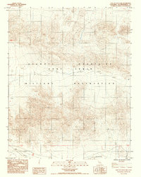
1984 Map of East of Leach Lake
USGS Topo · Published 1988About this map
The high-desert terrain of the Avawatz Mountains dominates this 1980s topographic study within the Fort Irwin Military Reservation. This survey, compiled from late 1970s aerial photography, captures the stark geography of San Bernardino County before modern developments altered the access patterns of the region. The map tracks numerous 4wd routes that thread through steep contour intervals, reflecting the difficult navigation of this protected military landscape. In the southern reaches, the dry basin of Drinkwater Lake provides a rare level landmark among the complex ridges. Several vertical control stations, including BM 2546 and BM JRH 34x, are carefully plotted, providing precise elevation data for geologists and desert researchers studying these arid slopes.
Find a feature on this map
15 named features on this map. Tap any name to fly to it.
Don’t see what you’re looking for? This feature index may not catch every label — zoom into the map to look around manually.
Map Details
Editions of this 1984 East of Leach Lake Map
2 editions found
Other maps of this area

1933 · Avawatz Mountains
USGS Topo · 1:250,000

1947 · Trona
USGS Topo · 1:250,000

1948 · Red Pass Lake
USGS Topo · 1:62,500

1948 · Trona
USGS Topo · 1:250,000

1948 · Leach Lake
USGS Topo · 1:62,500

1948 · Avawatz Pass
USGS Topo · 1:62,500

1948 · Tiefort Mountains
USGS Topo · 1:62,500

1951 · Tiefort Mountains
USGS Topo · 1:62,500

1951 · Avawatz Pass
USGS Topo · 1:62,500

1951 · Red Pass Lake
USGS Topo · 1:62,500