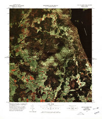
1978 Map of East of North Troy Station
USGS Topo · Published 1978About this map
The international boundary between Canada and the United States bisects this Vermont landscape, where the waters of Lake Memphremagog meet the shoreline at Magoon Point. This photo-rectified survey, produced in cooperation with the U.S. Customs Service, highlights the trans-border connectivity of the late 1970s. The Canadian Pacific railroad cuts through the southern half of the sheet, passing Summit Siding and following the course of Mud Creek. Dominating the central terrain is the massive profile of Bear Mountain, flanked by other prominent heights such as Province Hill and Allen Hill. The settlement of Leadville appears near the intersection of Leadville Road and Lake Road, illustrating the rural development patterns in this border region. The mix of cleared fields and dense forest reflects the enduring agricultural and timber character of Orleans County during this era.
Find a feature on this map
15 named features on this map. Tap any name to fly to it.
Don’t see what you’re looking for? This feature index may not catch every label — zoom into the map to look around manually.
Map Details
Editions of this 1978 East of North Troy Station Map
This is the sole edition of this map. No revisions or reprints were ever made.
Other maps of this area

1919 · Lake Memphremagog
USGS Topo · 1:62,500

1920 · Derby
USGS Topo · 1:62,500

1920 · Irasburg
USGS Topo · 1:62,500

1923 · Irasburg
USGS Topo · 1:48,000

1923 · Lake Memphremagog
USGS Topo · 1:48,000

1925 · Irasburg
USGS Topo · 1:62,500

1925 · Memphremagog
USGS Topo · 1:62,500

1950 · Lake Champlain
USGS Topo · 1:250,000

1953 · Irasburg
USGS Topo · 1:62,500
1953 · Memphremagog
USGS Topo · 1:62,500