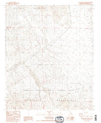
1987 Map of East of Red Canyon
USGS Topo · Published 1987About this map
The Chocolate Mountain Aerial Gunnery Range dominates the southern half of this landscape, marking a significant military aviation corridor defined by the Naval Reservation Boundary. This 1987 edition illustrates the intersection of desert wilderness and historical transit, where the old Bradshaw Road cuts across the arid basin between the Orocopia Mountains and the Chocolate Mountains. Small-scale historical activity is evidenced by a prospect in the north and the isolated Tabaseca Tank to the south. The drainage of Salt Creek provides a central geographic anchor, winding through the valley floor beneath the Chuckwalla Mountains. This map reflects a moment when vast stretches of the California desert were managed for both defense and preservation, prior to later shifts in land use and expanded recreation access.
Find a feature on this map
17 named features on this map. Tap any name to fly to it.
Don’t see what you’re looking for? This feature index may not catch every label — zoom into the map to look around manually.
Map Details
Editions of this 1987 East of Red Canyon Map
2 editions found
Other maps of this area

1940 · Frink
USGS Topo · 1:62,500

1940 · Iris Pass
USGS Topo · 1:62,500

1940 · Canyon Spring
USGS Topo · 1:62,500

1943 · Canyon Spring
USGS Topo · 1:62,500

1944 · Chuckwalla Mountains
USGS Topo · 1:62,500

1944 · Frink
USGS Topo · 1:62,500

1945 · Iris Pass
USGS Topo · 1:62,500

1954 · Salton Sea
USGS Topo · 1:250,000

1955 · Salton Sea
USGS Topo · 1:250,000

1956 · Frink NW
USGS Topo · 1:24,000