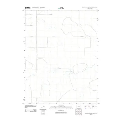
2010 Map of East of Sevenmile Ranch
USGS Topo · Published 2010About this map
The South Fork Republican River winds through the southern reaches of this Lincoln County landscape, defining the hydrology of a region dominated by a geometric grid of rural transit. In the early 21st century, this section of eastern Colorado remains characterized by its sprawling agricultural layout, where the straight lines of County Road N and County Road P contrast with the meandering path of the river and its tributaries. To the north, Duck Creek cuts across the corner of the survey, passing under County Rd 3E. The map illustrates a high plains environment where the infrastructure is built almost entirely around section-line roads like County Rd 2Z and County Rd G, facilitating movement through an area focused on ranching and large-scale land management.
Find a feature on this map
17 named features on this map. Tap any name to fly to it.
Don’t see what you’re looking for? This feature index may not catch every label — zoom into the map to look around manually.
Map Details
Editions of this 2010 East of Sevenmile Ranch Map
This is the sole edition of this map. No revisions or reprints were ever made.
Other maps of this area

1954 · Limon
USGS Topo · 1:250,000

1957 · Limon
USGS Topo · 1:250,000

1958 · Limon
USGS Topo · 1:250,000

1978 · Clifford
USGS Topo · 1:24,000

1978 · Hugo 4 NW
USGS Topo · 1:24,000

1979 · Sevenmile Ranch
USGS Topo · 1:24,000
1979 · Clifford
USGS Topo · 1:24,000

1979 · Hugo 4 NE
USGS Topo · 1:24,000

1979 · Arriba
USGS Topo · 1:24,000

1979 · Flagler SW
USGS Topo · 1:24,000