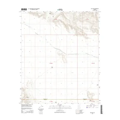
2014 Map of East Pass
USGS Topo · Published 2014About this map
East Pass serves as a distinct corridor through the volcanic landscape of the Crater Range, providing a natural transit point in this arid stretch of the Sonoran Desert. To the south, the Growler Mountains and Childs Mountain flank the broad expanse of Childs Valley, a region defined by its drainage patterns and extreme isolation. The map illustrates the hydrological importance of ephemeral systems like Tenmile Wash and Daniels Arroyo, which cut through the terrain to shape the local geography. This 2014 survey documents the boundary between Maricopa Co and Pima Co, capturing the township and range divisions that structure this sparsely settled borderland. The area's character is defined by its massive basaltic formations and dry alluvial plains, offering a detailed look at the geomorphology of Southwestern Arizona.
Find a feature on this map
14 named features on this map. Tap any name to fly to it.
Don’t see what you’re looking for? This feature index may not catch every label — zoom into the map to look around manually.
Map Details
Editions of this 2014 East Pass Map
This is the sole edition of this map. No revisions or reprints were ever made.
Other maps of this area
1932 · Ajo
USGS Topo · 1:62,500
1934 · Ajo
USGS Topo · 1:62,500

1953 · Ajo
USGS Topo · 1:250,000

1957 · Ajo
USGS Topo · 1:250,000

1958 · Ajo
USGS Topo · 1:250,000
1958 · Midway
USGS Topo · 1:62,500

1962 · Ajo
USGS Topo · 1:250,000

1963 · Ajo
USGS Topo · 1:250,000
1963 · Ajo
USGS Topo · 1:62,500
1964 · Growler Peak
USGS Topo · 1:62,500