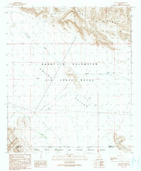
1990 Map of East Pass
USGS Topo · Published 1990About this map
The Barry M Goldwater Air Force Range dominates the central portion of this desert landscape, where military management overlaps with significant conservation efforts. To the south, the Cabeza Prieta Wilderness and National Wildlife Refuge marks a preserved arid ecosystem. This 1990 survey provides a detailed view of the rugged topography, including the Crater Range in the north and the Growler Mountains to the southwest. Between these heights lies Childs Valley, a wide drainage plain carved by Tenmile Wash. This era shows a landscape focused on resource management and preservation, with isolated features like a Corral and Water Tank Well suggesting the remnants of ranching activity within the larger protected areas of Pima and Maricopa counties.
Find a feature on this map
14 named features on this map. Tap any name to fly to it.
Don’t see what you’re looking for? This feature index may not catch every label — zoom into the map to look around manually.
Map Details
Editions of this 1990 East Pass Map
This is the sole edition of this map. No revisions or reprints were ever made.
Other maps of this area

1932 · Ajo
USGS Topo · 1:62,500

1934 · Ajo
USGS Topo · 1:62,500

1953 · Ajo
USGS Topo · 1:250,000

1957 · Ajo
USGS Topo · 1:250,000

1958 · Ajo
USGS Topo · 1:250,000

1958 · Midway
USGS Topo · 1:62,500

1962 · Ajo
USGS Topo · 1:250,000

1963 · Ajo
USGS Topo · 1:250,000

1963 · Ajo
USGS Topo · 1:62,500

1964 · Growler Peak
USGS Topo · 1:62,500