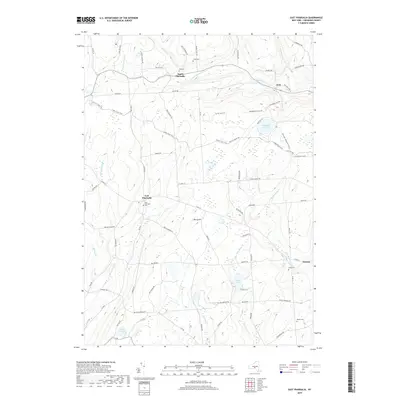
2019 Map of East Pharsalia
USGS Topo · Published 2019About this map
East Pharsalia and North Pharsalia anchor this section of Chenango County, characterized by a series of high ridges and deep creek valleys. The settlement at Kirk lies at the junction of Old State Rte 23 and Daniels Rd, while the uplands are dominated by the peak of Berry Hill. A network of utility and recreation routes, including the 9-Mile Truck Trail and Old CCC Truck Trl, winds through the dense terrain between Genegantslet Cr and Canasawacta Cr. For genealogists, the map preserves the exact locations of several burial grounds, such as East Pharsalia Cem and the Lewis Cem near Preston. The drainage patterns are well-defined by numerous waterways like Fly-Meadow Cr and Mill Brook, which feed into the Plymouth Reservoir. This modern survey reflects the enduring rural character of the region, where family-named roads like Elmer Jackson Rd and Fred Stewart Rd still define the local landscape.
Find a feature on this map
82 named features on this map. Tap any name to fly to it.
Don’t see what you’re looking for? This feature index may not catch every label — zoom into the map to look around manually.
Map Details
Editions of this 2019 East Pharsalia Map
This is the sole edition of this map. No revisions or reprints were ever made.
Other maps of this area

1902 · Coventry
USGS Topo · 1:62,500

1903 · Norwich
USGS Topo · 1:62,500

1904 · Greene
USGS Topo · 1:62,500

1904 · Oxford
USGS Topo · 1:62,500

1904 · Pitcher
USGS Topo · 1:62,500

1943 · Otselic
USGS Topo · 1:24,000

1943 · South Ostelic
USGS Topo · 1:24,000

1943 · Norwich
USGS Topo · 1:24,000

1943 · East Pharsalia
USGS Topo · 1:24,000
1943 · Earlville
USGS Topo · 1:24,000