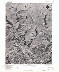
1976 Map of East Stroudsburg
USGS Topo · Published 1978About this map
East Stroudsburg serves as the primary urban center in this mid-1970s orthophotoquad, showing a transition from dense residential and commercial blocks to the outlying settlements of Monroe County. The imagery, captured in late 1976, reveals the transport corridors connecting Analomink and Gravel Place to the larger borough. Unlike standard topographic maps, this aerial perspective provides a literal view of the land use, from the clearings at Marshall Creek to the secluded waters of Lake Monroe. The map documents the expansion of neighborhoods and the winding road networks leading north toward Wooddale, reflecting the area's development during a period of growth in the Poconos region. It is a valuable resource for observing exact forest cover, building footprints, and the real-world state of the landscape before further modern subdivision.
Find a feature on this map
6 named features on this map. Tap any name to fly to it.
Don’t see what you’re looking for? This feature index may not catch every label — zoom into the map to look around manually.
Map Details
Editions of this 1976 East Stroudsburg Map
This is the sole edition of this map. No revisions or reprints were ever made.
Other maps of this area

1891 · Delaware Water Gap
USGS Topo · 1:62,500

1893 · Delaware Water Gap
USGS Topo · 1:62,500

1914 · Wind Gap
USGS Topo · 1:62,500

1916 · Wind Gap
USGS Topo · 1:62,500

1919 · Pocono
USGS Topo · 1:62,500

1921 · Pocono
USGS Topo · 1:62,500

1923 · Pocono
USGS Topo · 1:62,500

1924 · Bushkill
USGS Topo · 1:48,000

1936 · Delaware Water Gap
USGS Topo · 1:48,000

1941 · Delaware Water Gap
USGS Topo · 1:62,500
Featured Places
- Paradise Township, PA
- Analomink, Stroud Township
- Marshalls Creek, Smithfield Township
- Middle Smithfield Township, PA
- Arlington Heights, Stroud Township