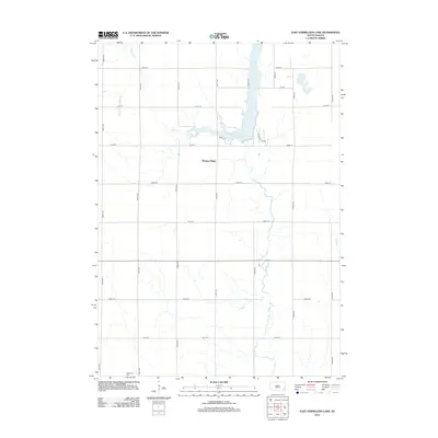
2012 Map of East Vermillion Lake
USGS Topo · Published 2012About this map
The East Fork Vermillion River Reservoir dominates this landscape, created by the impoundment of the East Fork Vermillion River north of the crossing at Quail Dr. This rural South Dakota region displays a strictly maintained section-line road grid, including 260th St and 450th Ave, which defines the agricultural character of the era. To the west, the winding path of Battle Cr cuts through the plains, while Elce Cr drains the southeastern corner of the quadrangle. Local landmarks include the elevated ground of Rumpus Ridge and the Reformed Cem situated near the intersection of 448th Ave and 267th St, providing a clear focal point for genealogical research in this sparsely populated township.
Find a feature on this map
24 named features on this map. Tap any name to fly to it.
Don’t see what you’re looking for? This feature index may not catch every label — zoom into the map to look around manually.
Map Details
Editions of this 2012 East Vermillion Lake Map
This is the sole edition of this map. No revisions or reprints were ever made.
Other maps of this area

1898 · Parker
USGS Topo · 1:125,000

1955 · Sioux Falls
USGS Topo · 1:250,000

1958 · Sioux Falls
USGS Topo · 1:250,000

1964 · Montrose
USGS Topo · 1:24,000

1964 · Grass Lake
USGS Topo · 1:24,000

1964 · Canistota
USGS Topo · 1:24,000

1964 · Salem NE
USGS Topo · 1:24,000

1964 · Humboldt
USGS Topo · 1:24,000

1964 · East Vermillion Lake
USGS Topo · 1:24,000
1968 · Parker NE
USGS Topo · 1:24,000
Featured Places
- Humboldt Township, SD
- Rumpus Ridge, SD
- Wellington Township, SD
- Spring Valley Township, SD
- Canistota Township, SD