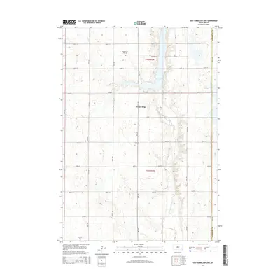
2015 Map of East Vermillion Lake
USGS Topo · Published 2015About this map
Coteau des Prairies, a vast plateau rising above the surrounding plains, dictates the drainage and topography of this eastern South Dakota landscape. The East Fork Vermillion River winds southward through the center of the sheet, widening into the significant reservoir of East Vermillion Lake. This waterway is fed by several tributaries, including Battle Cr and Flynn Cr, which cut through the undulating terrain of Rumpus Ridge. The map illustrates a disciplined section-line road grid typical of the Great Plains, where long stretches of 451st Ave and 265th St connect isolated agricultural homesteads. At the southern edge, the Reformed Cem sits near the township line, serving as a permanent record of the area's rural community and settlement history on the border of McCook and Minnehaha counties.
Find a feature on this map
31 named features on this map. Tap any name to fly to it.
Don’t see what you’re looking for? This feature index may not catch every label — zoom into the map to look around manually.
Map Details
Editions of this 2015 East Vermillion Lake Map
This is the sole edition of this map. No revisions or reprints were ever made.
Other maps of this area

1898 · Parker
USGS Topo · 1:125,000

1955 · Sioux Falls
USGS Topo · 1:250,000

1958 · Sioux Falls
USGS Topo · 1:250,000

1964 · Montrose
USGS Topo · 1:24,000

1964 · Grass Lake
USGS Topo · 1:24,000

1964 · Canistota
USGS Topo · 1:24,000

1964 · Salem NE
USGS Topo · 1:24,000

1964 · Humboldt
USGS Topo · 1:24,000

1964 · East Vermillion Lake
USGS Topo · 1:24,000
1968 · Parker NE
USGS Topo · 1:24,000
Featured Places
- Humboldt Township, SD
- Rumpus Ridge, SD
- Wellington Township, SD
- Spring Valley Township, SD
- Canistota Township, SD