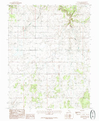
1985 Map of Eastland NW
USGS Topo · Published 1985About this map
Iron Spring and the rugged drainage of Bear Trap Canyon define this high-plateau landscape in San Juan County. This 1980s topographical record captures a transitional period of resource management in southeastern Utah, marked by the long utility lines of a prominent Pipeline cutting across the mesas. The drainage patterns of Boulder Creek and East Canyon reveal the complex erosion of the regional geography, where seasonal water sources and deep-cut canyons dictated the utility and movement across this arid terrain. The map serves as a snapshot of the backcountry prior to modern landscape shifts, emphasizing natural water features and the industrial footprint of energy transport in the American West.
Find a feature on this map
5 named features on this map. Tap any name to fly to it.
Don’t see what you’re looking for? This feature index may not catch every label — zoom into the map to look around manually.
Map Details
Editions of this 1985 Eastland NW Map
This is the sole edition of this map. No revisions or reprints were ever made.
Other maps of this area

1885 · La Sal
USGS Topo · 1:250,000

1886 · Abajo
USGS Topo · 1:250,000

1892 · Abajo
USGS Topo · 1:250,000

1893 · Abajo
USGS Topo · 1:250,000

1954 · Mt Peale 3 SE
USGS Topo · 1:24,000
1954 · Mt Peale 4 SE
USGS Topo · 1:24,000

1954 · Mt Peale 4 SW
USGS Topo · 1:24,000
1954 · Lisbon Valley
USGS Topo · 1:62,500
1954 · Hatch Rock
USGS Topo · 1:62,500

1955 · Verdure 2 SE
USGS Topo · 1:24,000