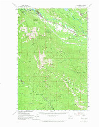
1961 Map of Easton
USGS Topo · Published 1967About this map
Easton serves as a critical junction for mountain transit in the early 1960s, situated where the Yakima River meets the heavy rail corridors of the Northern Pacific and the Chicago Milwaukee St Paul and Pacific. The landscape is defined by the high ridges of the Wenatchee National Forest, which separate the river valleys from industrial pockets like the Roslyn-Cascade Mine 4 and a nearby strip mine near Ronald.
Find a feature on this map
76 named features on this map. Tap any name to fly to it.
Don’t see what you’re looking for? This feature index may not catch every label — zoom into the map to look around manually.
Map Details
Editions of this 1961 Easton Map
2 editions found

Other maps of this area

1897 · Mount Stuart
USGS Topo · 1:125,000

1899 · Ellensburg
USGS Topo · 1:125,000

1901 · Ellensburg
USGS Topo · 1:125,000

1901 · Snoqualmie Pass
USGS Topo · 1:125,000

1902 · Mount Aix
USGS Topo · 1:125,000

1902 · Mount Stuart
USGS Topo · 1:125,000

1903 · Snoqualmie
USGS Topo · 1:125,000

1904 · Mt Aix
USGS Topo · 1:125,000

1950 · Yakima
USGS Topo · 1:250,000

1957 · Wenatchee
USGS Topo · 1:250,000