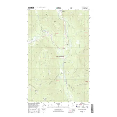
2017 Map of Eastport
USGS Topo · Published 2017About this map
Eastport sits at the northern edge of this territory where the Moyie River and the Union Pacific railroad line parallel Us HWY 95 as it heads toward the Canadian border. The rugged topography of the Purcell Mountains and the Kaniksu National Forest defines the landscape, marked by significant elevations like Queen Mtn and Bussard Mtn. Historically significant mining operations, including the Queen Mine and Tilly Mine, are located on the western slopes, reflecting the region's extraction heritage. Small settlements like Addie, Sinclair, and the uniquely named Good Grief dot the river valley. For hikers and conservationists, the Pacific NW National Scenic Trail winds through the southern and eastern ridges, connecting high points like Ruby Ridge with the valley floor near Bussard Lake. The map details a network of forest roads and creek systems, such as Hellroaring Cr and Snyder Creek, which drain the steep surrounding peaks.
Find a feature on this map
55 named features on this map. Tap any name to fly to it.
Don’t see what you’re looking for? This feature index may not catch every label — zoom into the map to look around manually.
Map Details
Editions of this 2017 Eastport Map
This is the sole edition of this map. No revisions or reprints were ever made.
Other maps of this area

1911 · Priest Lake
USGS Topo · 1:250,000

1913 · Priest Lake
USGS Topo · 1:250,000

1958 · Sandpoint
USGS Topo · 1:250,000

1963 · Sandpoint
USGS Topo · 1:250,000

1965 · Meadow Creek
USGS Topo · 1:24,000

1965 · Eastport
USGS Topo · 1:24,000

1965 · Ritz
USGS Topo · 1:24,000
1965 · Line Point
USGS Topo · 1:24,000
1965 · Canuck Peak
USGS Topo · 1:24,000

1965 · Hall Mountain
USGS Topo · 1:24,000