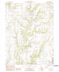
1985 Map of Eaton
USGS Topo · Published 1985About this map
The unincorporated community of Porterville (Eaton) serves as the central hub of this mid-1980s Crawford County landscape, where the agricultural traditions of the Prairie intersect with the local petroleum industry. The terrain is defined by a dense network of productive Oil Fields scattered across the township boundaries of Licking, Oblong, and Robinson. This economic activity is set against a complex hydrological system featuring Big Creek, Onion Creek, and Grassy Creek, which carve through the level fields. Near the southern edge, the residential area of West Lake and a nearby Golf Course indicate the shifting land use toward recreation and rural housing during this era. A prominent Radio Tower stands near the eastern border, serving as a modern landmark for the surrounding farmland and industrial sites.
Find a feature on this map
18 named features on this map. Tap any name to fly to it.
Don’t see what you’re looking for? This feature index may not catch every label — zoom into the map to look around manually.
Map Details
Editions of this 1985 Eaton Map
This is the sole edition of this map. No revisions or reprints were ever made.
Other maps of this area

1910 · Hardinville
USGS Topo · 1:62,500

1917 · Birds
USGS Topo · 1:62,500

1942 · Birds
USGS Topo · 1:62,500

1953 · Indianapolis
USGS Topo · 1:250,000

1956 · Indianapolis
USGS Topo · 1:250,000

1956 · Annapolis
USGS Topo · 1:62,500

1956 · Vincennes
USGS Topo · 1:250,000

1957 · Indianapolis
USGS Topo · 1:250,000

1957 · Vincennes
USGS Topo · 1:250,000

1957 · Hutsonville
USGS Topo · 1:62,500