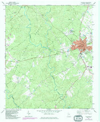
1972 Map of Eatonton
USGS Topo · Published 1986About this map
Eatonton serves as the regional hub in this 1970s Georgia landscape, situated at the junction of the Central of Georgia railroad and local thoroughfares. The town center is well-defined by civic landmarks including the City Hall, Po, and a Museum, while Eatonton High Sch and Gatewood Academy anchor the local community. To the north and west, the dense woodlands of the Oconee National Forest dominate the terrain, dissected by the winding courses of the Little River and Murder Creek.
Find a feature on this map
40 named features on this map. Tap any name to fly to it.
Don’t see what you’re looking for? This feature index may not catch every label — zoom into the map to look around manually.
Map Details
Editions of this 1972 Eatonton Map
2 editions found
Other maps of this area

1953 · Athens
USGS Topo · 1:250,000

1958 · Athens
USGS Topo · 1:250,000

1959 · Athens
USGS Topo · 1:250,000

1963 · Athens
USGS Topo · 1:250,000

1964 · Stanfordville
USGS Topo · 1:24,000

1972 · Meda
USGS Topo · 1:24,000

1972 · Eatonton
USGS Topo · 1:24,000

1972 · Shady Dale
USGS Topo · 1:24,000
1972 · Smithboro
USGS Topo · 1:24,000

1972 · Harmony
USGS Topo · 1:24,000