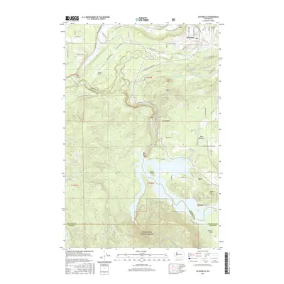
2017 Map of Eatonville
USGS Topo · Published 2017About this map
Eatonville serves as the focal point of this Pierce County landscape, where the Mashel River meets the Eatonville Mill Pond near Swanson Airport. The terrain transitions from the low-lying Ohop Valley and Mashel Prairie in the northwest to the more significant elevations of Hugo Peak and Kirkland Pass. The southern portion of the map is dominated by the waters of Alder Lake, a man-made reservoir on the Nisqually River that displaced or reshaped local communities. Several small settlements and rural neighborhoods like Alder, Reliance, and New Reliance are situated along the eastern shores and hillsides. The influence of the timber industry and hydroelectric power is evident in the managed lands of the Snoqualmie National Forest and the presence of the La Grande Reservoir. Transportation networks include local routes like the Eatonville LaGrande Rd and the Scott Turner Rd E, which connect these river-valley communities across the county lines of Pierce, Thurston, and Lewis.
Find a feature on this map
91 named features on this map. Tap any name to fly to it.
Don’t see what you’re looking for? This feature index may not catch every label — zoom into the map to look around manually.
Map Details
Editions of this 2017 Eatonville Map
This is the sole edition of this map. No revisions or reprints were ever made.
Other maps of this area

1937 · Eatonville
USGS Topo · 1:125,000

1941 · Tanwax Lake
USGS Topo · 1:62,500

1944 · Ohop Valley
USGS Topo · 1:62,500

1949 · Ohop Valley
USGS Topo · 1:62,500

1953 · Hoquiam
USGS Topo · 1:250,000

1956 · Mineral
USGS Topo · 1:62,500

1956 · Kapowsin
USGS Topo · 1:62,500

1957 · Hoquiam
USGS Topo · 1:250,000

1957 · Morton
USGS Topo · 1:62,500

1958 · Hoquiam
USGS Topo · 1:250,000