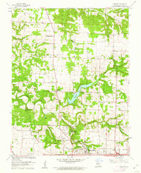
1961 Map of Ebenezer
USGS Topo · Published 1962About this map
Springfield expands northward toward the rural townships of Robberson and North Campbell in this early 1960s topographic record. The landscape is defined by the winding course of the Little Sac River and the significant reservoir of McDaniel Lake, which serve as central geographic anchors for the surrounding countryside. This region is notable for its karst topography, clearly marked by the presence of Fantastic Caverns and Crystal Cave, indicating the unique subterranean character of the Missouri Ozarks near the city.
Find a feature on this map
35 named features on this map. Tap any name to fly to it.
Don’t see what you’re looking for? This feature index may not catch every label — zoom into the map to look around manually.
Map Details
Editions of this 1961 Ebenezer Map
3 editions found

Other maps of this area

1884 · Springfield
USGS Topo · 1:125,000

1886 · Springfield
USGS Topo · 1:125,000

1935 · Springfield
USGS Topo · 1:24,000

1936 · Brookline
USGS Topo · 1:24,000

1937 · Galloway
USGS Topo · 1:24,000

1937 · Ozark
USGS Topo · 1:48,000

1943 · Ozark
USGS Topo · 1:62,500

1945 · Ozark
USGS Topo · 1:62,500

1946 · Bassville
USGS Topo · 1:24,000

1947 · Strafford
USGS Topo · 1:62,500