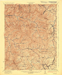
1932 Map of Eccles
USGS Topo · Published 1932About this map
The rugged coal-bearing country of Raleigh County, West Virginia, is defined by the steep ridges of Coal River Mountain and Guyandot Mountain in this 1932 edition. This survey reveals a dense network of isolated mountain schools and rural settlements established before modern consolidation, including McKinley School, Today Fork School, and the community of Glen Daniel. The landscape is carved by the deep valleys of the Marsh Fork and Clear Fork of the Coal River, where the Chesapeake And Ohio and Virginian railroads snake through the terrain to serve mining towns like Eccles and Pax. This era of the Southern West Virginia coalfields is captured in detail, showing a way of life centered on small company towns, local fords, and numerous family-named knobs such as Squealer Knob and Ivy Knob.
Find a feature on this map
90 named features on this map. Tap any name to fly to it.
Don’t see what you’re looking for? This feature index may not catch every label — zoom into the map to look around manually.
Map Details
Editions of this 1932 Eccles Map
3 editions found
Other maps of this area

1891 · Oceana
USGS Topo · 1:125,000

1891 · Raleigh
USGS Topo · 1:125,000

1893 · Oceana
USGS Topo · 1:125,000

1897 · Kanawha Falls
USGS Topo · 1:125,000

1897 · Raleigh
USGS Topo · 1:125,000

1898 · Oceana
USGS Topo · 1:125,000

1899 · Charleston
USGS Topo · 1:125,000

1900 · Kanawha Falls
USGS Topo · 1:125,000

1901 · Kanawha Falls
USGS Topo · 1:125,000

1902 · Raleigh
USGS Topo · 1:125,000