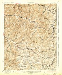
1932 Map of Eccles
USGS Topo · Published 1932About this map
Eccles and the surrounding coal country of Raleigh County are defined by deep mountain valleys and the dual rail lines of the Virginian and Chesapeake and Ohio railroads. This 1932 edition reflects a landscape shaped by early 20th-century extraction, where numerous small settlements like Ameagle, Dorothy, and Glen White are linked by the winding paths of the Marsh Fork and Clear Fork. The map reveals an incredible density of local institutions that supported these mining communities, including the Lick Fork School, Sandlick Caperton School, and Matville Church. Traversing the heights of Kayford Mountain and Chestnut Mountain, the survey documents a complex network of company towns and family-named landmarks such as Skinned Poplar Gap and Irish Lick Knob. This era represents the peak of rail-dependent transit before modern highway expansion altered the social geography of the southern West Virginia coalfields.
Find a feature on this map
144 named features on this map. Tap any name to fly to it.
Don’t see what you’re looking for? This feature index may not catch every label — zoom into the map to look around manually.
Map Details
Editions of this 1932 Eccles Map
3 editions found
Other maps of this area

1891 · Oceana
USGS Topo · 1:125,000

1891 · Raleigh
USGS Topo · 1:125,000

1893 · Oceana
USGS Topo · 1:125,000

1897 · Kanawha Falls
USGS Topo · 1:125,000

1897 · Raleigh
USGS Topo · 1:125,000

1898 · Oceana
USGS Topo · 1:125,000

1899 · Charleston
USGS Topo · 1:125,000

1900 · Kanawha Falls
USGS Topo · 1:125,000

1901 · Kanawha Falls
USGS Topo · 1:125,000

1902 · Raleigh
USGS Topo · 1:125,000