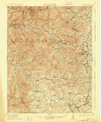
1914 Map of Eccles
USGS Topo · Published 1926About this map
Raleigh County and portions of Kanawha County and Fayette County are defined by the winding drainages of Marsh Fork and Clear Fork in this 1911 survey. The landscape is a dense network of mountain ridges and narrow hollows, where early 20th-century life centered around a remarkably high density of rural schoolhouses. Features like White Rose School, Meadow Inn School, and Sycamore School are scattered across the terrain, indicating a distributed population of mining and timber families long before the consolidation of mountain communities.
Find a feature on this map
105 named features on this map. Tap any name to fly to it.
Don’t see what you’re looking for? This feature index may not catch every label — zoom into the map to look around manually.
Map Details
Editions of this 1914 Eccles Map
2 editions found

Other maps of this area

1891 · Oceana
USGS Topo · 1:125,000

1891 · Raleigh
USGS Topo · 1:125,000

1893 · Oceana
USGS Topo · 1:125,000

1897 · Kanawha Falls
USGS Topo · 1:125,000

1897 · Raleigh
USGS Topo · 1:125,000

1898 · Oceana
USGS Topo · 1:125,000

1899 · Charleston
USGS Topo · 1:125,000

1900 · Kanawha Falls
USGS Topo · 1:125,000

1901 · Kanawha Falls
USGS Topo · 1:125,000

1902 · Raleigh
USGS Topo · 1:125,000