
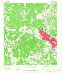
1964 Map of Echo Hill Ranch
USGS Topo · Published 1967About this map
The Medina River and its upper tributaries carve through the limestone-rich Hill Country during the mid-1960s, a period when this landscape was dominated by expansive private cattle and goat operations. Several prominent family holdings are documented, including the H Real Ranch, L Real Ranch, and A Real Ranch, reflecting the deep regional legacy of the Real family. The northern portion of the map is defined by the winding course of Cypress Creek and the Moore Lakes, while the southern reaches follow the Prong Medina River past the Medina Childrens Home. Geologic and topographic landmarks like White Bluff, Castle Rock, and the distinctive Slideoff provide orientation points across a terrain of deep hollows such as Harlow Hollow and Coker Hollow. The presence of a Gravel Pit and numerous wells indicates the localized extraction and water management essential for sustaining these large ranching estates.
Find a feature on this map
39 named features on this map. Tap any name to fly to it.
Don’t see what you’re looking for? This feature index may not catch every label — zoom into the map to look around manually.
Map Details
Editions of this 1964 Echo Hill Ranch Map
This is the sole edition of this map. No revisions or reprints were ever made.
Other maps of this area

1894 · Kerrville
USGS Topo · 1:125,000

1954 · Llano
USGS Topo · 1:250,000

1954 · San Antonio
USGS Topo · 1:250,000

1955 · Llano
USGS Topo · 1:250,000

1956 · Tuff
USGS Topo · 1:62,500

1956 · Center Point
USGS Topo · 1:62,500

1956 · Llano
USGS Topo · 1:250,000

1957 · San Antonio
USGS Topo · 1:250,000

1964 · Diamond S Ranch
USGS Topo · 1:24,000
1964 · Kerrville
USGS Topo · 1:24,000