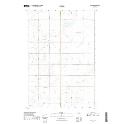
2018 Map of Eckelson SW
USGS Topo · Published 2018About this map
The Stutsman Co Barnes Co border divides this 2018 survey, which reveals a landscape of high-plains agriculture and glacial depressions. In the northern reaches of the quadrangle, Mud Lake serves as a prominent hydrological anchor, surrounded by numerous smaller seasonal wetlands that dot the prairie. The terrain is structured by a rigid section-line road grid, including 38th St SE and 96th Ave SE, reflecting the legacy of the Public Land Survey System. In the southwest corner, the topography shifts slightly with the presence of Streaman Coulee, a natural drainage feature that disrupts the otherwise consistent agricultural blocks. This map provides a clear record of modern rural infrastructure and land use, showing the distribution of farmsteads and field boundaries across the North Dakota plains.
Find a feature on this map
22 named features on this map. Tap any name to fly to it.
Don’t see what you’re looking for? This feature index may not catch every label — zoom into the map to look around manually.
Map Details
Editions of this 2018 Eckelson SW Map
This is the sole edition of this map. No revisions or reprints were ever made.
Other maps of this area

1896 · Jamestown
USGS Topo · 1:125,000

1897 · Eckelson
USGS Topo · 1:125,000

1952 · Ypsilanti
USGS Topo · 1:24,000

1952 · Bloom
USGS Topo · 1:24,000

1953 · Jamestown
USGS Topo · 1:250,000

1953 · Montpelier
USGS Topo · 1:24,000

1956 · Jamestown
USGS Topo · 1:250,000

1970 · Eckelson
USGS Topo · 1:24,000
1970 · Spiritwood
USGS Topo · 1:24,000

1970 · Marion NE
USGS Topo · 1:24,000