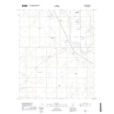
2018 Map of Eden
USGS Topo · Published 2018About this map
Gila River waters flow through this portion of the Gila Valley, sustaining a landscape where agricultural infrastructure and natural geological formations meet. The map reveals a complex system of irrigation essential to the region, including the Dodge Nevada Canal and Curtis Canal. Settlements such as Eden, Cork, and Ashurst are situated along these water routes, with local history preserved at the Ashurst Cem. To the east, the Indian Hot Springs and associated mineral sources like Magnesium Springs indicate the geothermal character of the area. The western terrain is defined by the striking Red Knolls and the Red Knolls Amphitheater, while various washes like Matthews Wash and Hunsacker Wash drain the higher elevations of Bear Springs Flat.
Find a feature on this map
44 named features on this map. Tap any name to fly to it.
Don’t see what you’re looking for? This feature index may not catch every label — zoom into the map to look around manually.
Map Details
Editions of this 2018 Eden Map
This is the sole edition of this map. No revisions or reprints were ever made.
Other maps of this area
1944 · Jackson Mtn.
USGS Topo · 1:62,500
1946 · Jackson Mtn.
USGS Topo · 1:62,500

1954 · Silver City
USGS Topo · 1:250,000

1954 · Clifton
USGS Topo · 1:250,000
1954 · Mesa
USGS Topo · 1:250,000

1956 · Tucson
USGS Topo · 1:250,000
1957 · Mesa
USGS Topo · 1:250,000

1957 · Clifton
USGS Topo · 1:250,000
1958 · Silver City
USGS Topo · 1:250,000

1958 · Clifton
USGS Topo · 1:250,000