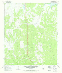
1970 Map of Eden SE
USGS Topo · Published 1973About this map
The Concho and Menard county border divides this 1970 landscape of the Edwards Plateau, where the drainage patterns of South Brady Creek and Celery Creek define the ranching terrain. The topography is characterized by intricate draws and breaks, including Volkmann Draw and West Scalp Creek, which reveal the area's geological composition. While predominantly rural and used for grazing, the map indicates early 1970s extractive industry through numerous Gravel Pits and an Oil Well near the western edge. Cultural landmarks are sparse, reflecting the low-density settlement typical of West Texas ranchlands, with the Whitehead Ranch serving as a primary local landmark. Significant infrastructure includes the Plum Thicket Windmill, a critical water source for livestock in this semi-arid environment during the late twentieth century.
Find a feature on this map
12 named features on this map. Tap any name to fly to it.
Don’t see what you’re looking for? This feature index may not catch every label — zoom into the map to look around manually.
Map Details
Editions of this 1970 Eden SE Map
2 editions found
Other maps of this area

1892 · Eden
USGS Topo · 1:125,000

1896 · Eden
USGS Topo · 1:125,000

1954 · Brownwood
USGS Topo · 1:250,000

1954 · Llano
USGS Topo · 1:250,000

1955 · Llano
USGS Topo · 1:250,000

1956 · Llano
USGS Topo · 1:250,000
1970 · Live Oak
USGS Topo · 1:24,000

1970 · Callan
USGS Topo · 1:24,000

1970 · Clear Creek Lake
USGS Topo · 1:24,000
1970 · Eden
USGS Topo · 1:24,000