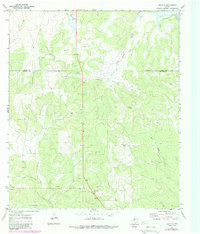
1970 Map of Eden SE
USGS Topo · Published 1988About this map
The rolling Edwards Plateau landscape of central Texas is captured here along the border of Concho and Menard Counties. The terrain is defined by a network of drainage systems including South Brady Creek, West Scalp Creek, and the winding Celery Creek, which shape the local ranching environment. Ranching infrastructure and sparse industrial activity are the primary human imprints on the land, most notably at the Whitehead Ranch and the isolated Plum Thicket Windmill. Surveyed in the late 1960s with updates through the 1980s, the map also documents localized resource extraction through numerous scattered Gravel Pits and an Oil Well. These features, along with Volkmann Draw, illustrate the traditional land use patterns of this rural sheep and cattle country before further modernization.
Find a feature on this map
12 named features on this map. Tap any name to fly to it.
Don’t see what you’re looking for? This feature index may not catch every label — zoom into the map to look around manually.
Map Details
Editions of this 1970 Eden SE Map
2 editions found
Other maps of this area

1892 · Eden
USGS Topo · 1:125,000

1896 · Eden
USGS Topo · 1:125,000

1954 · Brownwood
USGS Topo · 1:250,000

1954 · Llano
USGS Topo · 1:250,000

1955 · Llano
USGS Topo · 1:250,000

1956 · Llano
USGS Topo · 1:250,000
1970 · Live Oak
USGS Topo · 1:24,000

1970 · Callan
USGS Topo · 1:24,000

1970 · Clear Creek Lake
USGS Topo · 1:24,000
1970 · Eden
USGS Topo · 1:24,000