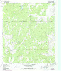
1970 Map of Eden SW
USGS Topo · Published 1988About this map
Negro Gap and the surrounding high ground along the Concho Co Menard Co line define this portion of the Edwards Plateau. The landscape is characterized by a network of drainage systems, including Live Oak Creek, Fitzgerald Creek, and Celery Creek, which carve through the terrain. In the late 1960s and early 1970s, the area's economy was heavily influenced by resource extraction, evidenced by an extensive Oil Field and numerous scattered Oil Wells and gravel pits. The presence of named landmarks like Millar, Lackey, and Jacoby suggests the enduring footprint of ranching and early landholding families in this rural part of Central Texas. Updated with 1983 aerial revisions, the map also captures utility infrastructure such as a Pipeline and a Spillway located near the headwaters of Live Oak Creek.
Find a feature on this map
18 named features on this map. Tap any name to fly to it.
Don’t see what you’re looking for? This feature index may not catch every label — zoom into the map to look around manually.
Map Details
Editions of this 1970 Eden SW Map
2 editions found
Other maps of this area

1892 · San Angelo
USGS Topo · 1:125,000

1892 · Eden
USGS Topo · 1:125,000

1893 · Fort McKavett
USGS Topo · 1:125,000

1896 · Eden
USGS Topo · 1:125,000

1954 · Brownwood
USGS Topo · 1:250,000

1954 · Llano
USGS Topo · 1:250,000

1954 · Sonora
USGS Topo · 1:250,000

1954 · San Angelo
USGS Topo · 1:250,000

1955 · Llano
USGS Topo · 1:250,000

1956 · Llano
USGS Topo · 1:250,000