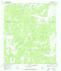
1970 Map of Eden SW
USGS Topo · Published 1973About this map
Negro Gap and the surrounding drainage basins of the San Saba River watershed define this landscape along the border of Concho County and Menard County. In the early 1970s, the region was characterized by a rural extractive economy, evidenced by the numerous scattered Gravel Pits and widespread energy infrastructure. An extensive Oil Field is documented here, with a dense network of Oil Wells and a prominent Pipeline cutting through the western terrain. The natural hydrology is marked by the seasonal flows of Live Oak Creek and Dry North Fork Creek, with a localized Spillway managing water movement in the north. This survey provides a precise record of the land use patterns during a period of active resource development in Central Texas, showing the intersection of industrial sites like Storage Bins with the natural topography of the Edwards Plateau.
Find a feature on this map
14 named features on this map. Tap any name to fly to it.
Don’t see what you’re looking for? This feature index may not catch every label — zoom into the map to look around manually.
Map Details
Editions of this 1970 Eden SW Map
2 editions found
Other maps of this area

1892 · San Angelo
USGS Topo · 1:125,000

1892 · Eden
USGS Topo · 1:125,000

1893 · Fort McKavett
USGS Topo · 1:125,000

1896 · Eden
USGS Topo · 1:125,000

1954 · Brownwood
USGS Topo · 1:250,000

1954 · Llano
USGS Topo · 1:250,000

1954 · Sonora
USGS Topo · 1:250,000

1954 · San Angelo
USGS Topo · 1:250,000

1955 · Llano
USGS Topo · 1:250,000

1956 · Llano
USGS Topo · 1:250,000