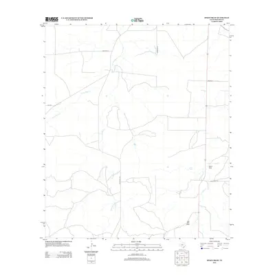
2012 Map of Spoon Draw
USGS Topo · Published 2012About this map
Vaughn Spring serves as a critical water source in this dry stretch of the Edwards Plateau, where the landscape is defined by intermittent drainage systems. The network of seasonal waterways including W Las Moras Cr and Las Moras Cr illustrates the typical West Texas pattern of relief, where water only moves during significant rain events. The presence of Spoon Draw and Cole Well Draw further emphasizes the importance of these topographic depressions for managing livestock and tracing historical land use in Menard County.
Find a feature on this map
12 named features on this map. Tap any name to fly to it.
Don’t see what you’re looking for? This feature index may not catch every label — zoom into the map to look around manually.
Map Details
Editions of this 2012 Spoon Draw Map
This is the sole edition of this map. No revisions or reprints were ever made.
Other maps of this area

1954 · Llano
USGS Topo · 1:250,000

1955 · Llano
USGS Topo · 1:250,000

1956 · Llano
USGS Topo · 1:250,000

1970 · Clear Creek Lake
USGS Topo · 1:24,000

1970 · San Augustine Draw
USGS Topo · 1:24,000

1970 · Julio Draw
USGS Topo · 1:24,000
1970 · Rust Ranch
USGS Topo · 1:24,000

1970 · Brewer Hollow
USGS Topo · 1:24,000

1970 · East Elm Creek
USGS Topo · 1:24,000
1970 · Spoon Draw
USGS Topo · 1:24,000