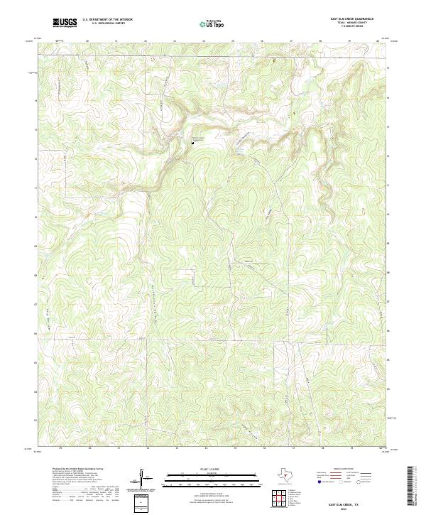
2022 Map of East Elm Creek
USGS Topo · Published 2022About this map
The William James Vaughan Cem serves as a quiet focal point in this portion of Menard County, where the landscape is defined by the dendritic drainage patterns of the Elm Cr system. This area is characterized by significant topographic relief, with numerous named draws and hollows such as Fox Hollow, North Coon Hollow, and Hog Hollow cutting through the limestone terrain. The presence of Coleman Spring and Coleman Spring Draw underscores the importance of reliable water sources in this ranching country.
Find a feature on this map
26 named features on this map. Tap any name to fly to it.
Don’t see what you’re looking for? This feature index may not catch every label — zoom into the map to look around manually.
Map Details
Editions of this 2022 East Elm Creek Map
This is the sole edition of this map. No revisions or reprints were ever made.
Other maps of this area

1954 · Llano
USGS Topo · 1:250,000

1955 · Llano
USGS Topo · 1:250,000

1956 · Llano
USGS Topo · 1:250,000

1968 · London
USGS Topo · 1:24,000

1970 · Julio Draw
USGS Topo · 1:24,000

1970 · Brewer Hollow
USGS Topo · 1:24,000

1970 · East Elm Creek
USGS Topo · 1:24,000
1970 · Hext
USGS Topo · 1:24,000
1970 · Spoon Draw
USGS Topo · 1:24,000
1970 · Robbers Roost
USGS Topo · 1:24,000