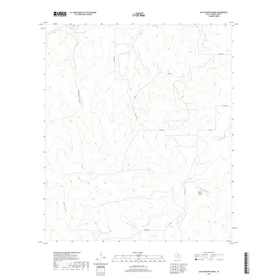
2019 Map of San Augustine Draw
USGS Topo · Published 2019About this map
San Augustines Springs and the headwaters of the San Saba River anchor the northern landscape of this Menard County region. The terrain is defined by a series of branching drainage systems, including the namesake San Augustine Draw and Sheen Draw, which carve through the plateau toward the river valley. The map reveals a rural network of ranch roads and lanes, many bearing family names that suggest a long history of local landownership, such as Ellis School Ln, Bradford Ln, and Benson Rd. A notable modern landmark, the Womack Ranch Airport, sits in the southeastern quadrant, reflecting the continued importance of private aviation in managing large Texas landholdings. This 2019 survey captures the intersection of traditional cattle-country geography with modern infrastructure, where seasonal creeks like W Las Moras Cr and Fields Cr remain central to the area's identity.
Find a feature on this map
15 named features on this map. Tap any name to fly to it.
Don’t see what you’re looking for? This feature index may not catch every label — zoom into the map to look around manually.
Map Details
Editions of this 2019 San Augustine Draw Map
This is the sole edition of this map. No revisions or reprints were ever made.
Other maps of this area

1893 · Fort McKavett
USGS Topo · 1:125,000

1954 · Llano
USGS Topo · 1:250,000

1954 · Sonora
USGS Topo · 1:250,000

1955 · Llano
USGS Topo · 1:250,000

1956 · Llano
USGS Topo · 1:250,000

1958 · Sonora
USGS Topo · 1:250,000

1963 · McKegan Draw NE
USGS Topo · 1:24,000

1970 · Clear Creek Lake
USGS Topo · 1:24,000

1970 · San Augustine Draw
USGS Topo · 1:24,000

1970 · Julio Draw
USGS Topo · 1:24,000