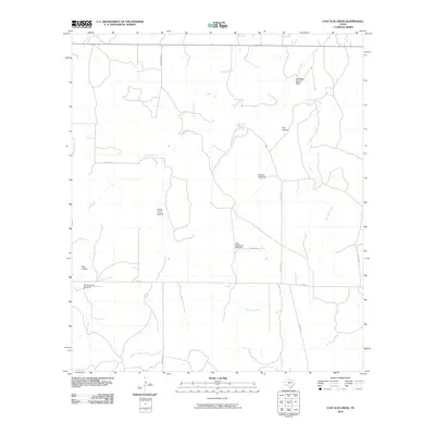
2010 Map of East Elm Creek
USGS Topo · Published 2010About this map
Nooksie Windmill and High Lonesome Windmill stand as prominent markers in this arid stretch of Menard County, indicating the essential role of groundwater management for the local ranching economy. The landscape is defined by a dendritic network of drainages, most notably Elm Creek and East Elm Creek, which have carved out distinct topographic features such as North Coon Hollow and Fox Hollow. The drainage pattern suggests a terrain of seasonal waterflow and limestone-influenced geology, where Coleman Spring provides a rare localized water source.
Find a feature on this map
20 named features on this map. Tap any name to fly to it.
Don’t see what you’re looking for? This feature index may not catch every label — zoom into the map to look around manually.
Map Details
Editions of this 2010 East Elm Creek Map
This is the sole edition of this map. No revisions or reprints were ever made.
Other maps of this area

1954 · Llano
USGS Topo · 1:250,000

1955 · Llano
USGS Topo · 1:250,000

1956 · Llano
USGS Topo · 1:250,000

1968 · London
USGS Topo · 1:24,000

1970 · Julio Draw
USGS Topo · 1:24,000

1970 · Brewer Hollow
USGS Topo · 1:24,000

1970 · East Elm Creek
USGS Topo · 1:24,000
1970 · Hext
USGS Topo · 1:24,000
1970 · Spoon Draw
USGS Topo · 1:24,000
1970 · Robbers Roost
USGS Topo · 1:24,000