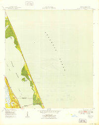
1950 Map of Eden
USGS Topo · Published 1950About this map
Hutchinson Island dominates the Atlantic coast in this mid-century coastal study, separating the Atlantic Ocean from the Indian River. The narrow barrier island is marked by significant inlets and bays, including Blind Creek and Herman Bay, with the isolated Nettles Island tucked within the river's expanse. Along the western shore, the Florida East Coast railway runs parallel to the coastline, serving the early settlements of Eden and Jensen Beach.
Find a feature on this map
16 named features on this map. Tap any name to fly to it.
Don’t see what you’re looking for? This feature index may not catch every label — zoom into the map to look around manually.
Map Details
Editions of this 1950 Eden Map
This is the sole edition of this map. No revisions or reprints were ever made.
Other maps of this area

1948 · Palm City
USGS Topo · 1:24,000

1948 · Ankona
USGS Topo · 1:24,000

1948 · St. Lucie Inlet
USGS Topo · 1:24,000

1948 · Eden
USGS Topo · 1:24,000

1949 · Fort Pierce
USGS Topo · 1:24,000

1950 · St. Lucie Inlet
USGS Topo · 1:24,000

1950 · Ankona
USGS Topo · 1:24,000

1950 · Fort Pierce
USGS Topo · 1:24,000

1950 · Palm City
USGS Topo · 1:24,000

1956 · Fort Pierce
USGS Topo · 1:250,000