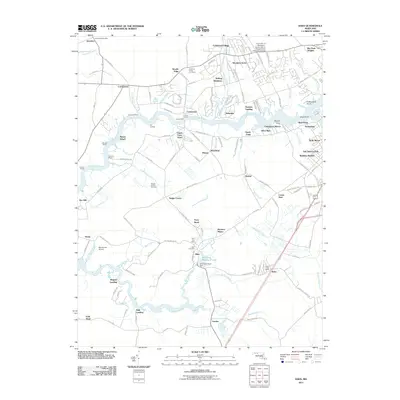
2011 Map of Eden
USGS Topo · Published 2011About this map
The Wicomico River and its labyrinth of tidal tributaries, including Quantico Creek and Passerdyke Creek, define the landscape of this southern Maryland region. A legacy of maritime and agricultural commerce is evident through numerous landing sites like Quantico Wharf, Parrotts Wharf, and Cox Landing. The interior reveals a pattern of rural settlements and modern residential developments such as Centennial Village, Woods Edge, and Nithsdale. Genealogists and local historians can locate the Allen Cemetery near the Allen Post Office, while the presence of the Quantico Forest Fire Tower and the Garden of Eden Orchards points to the area's managed natural resources. Educational and scientific interests are anchored by the University of Maryland - Eastern Shore Research and Education Center in the north, contrasting with the river crossings at Union Ferry and Upper Ferry that maintain long-standing transit corridors across the water.
Find a feature on this map
144 named features on this map. Tap any name to fly to it.
Don’t see what you’re looking for? This feature index may not catch every label — zoom into the map to look around manually.
Map Details
Editions of this 2011 Eden Map
This is the sole edition of this map. No revisions or reprints were ever made.
Other maps of this area

1901 · Salisbury
USGS Topo · 1:62,500

1903 · Nanticoke
USGS Topo · 1:62,500

1903 · Deal Island
USGS Topo · 1:62,500

1942 · Monie
USGS Topo · 1:24,000

1942 · Wetipquin
USGS Topo · 1:24,000

1942 · Princess Anne
USGS Topo · 1:24,000

1942 · Mardela Springs
USGS Topo · 1:24,000

1942 · Eden
USGS Topo · 1:24,000

1942 · Hebron
USGS Topo · 1:24,000

1942 · Dividing Creek
USGS Topo · 1:24,000