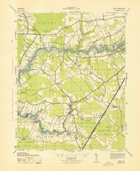
1943 Map of Eden
USGS Topo · Published 1943About this map
The Wicomico River carves a deep, winding path through the heart of this coastal Maryland landscape, where mid-century life was defined by river crossings and small crossroads communities. Rural settlements such as Catchpenny and Siloam are connected by a network of local roads leading to critical transit points like Upper Ferry. The map captures a unique social and health landscape of the era, including the Pine Bluff Sanitarium near Shad Point and the Quantico Forest Fire Lookout Tower standing watch over the northern woods. In the south, the Pennsylvania railroad line serves the town of Eden and provides a transit corridor between Wicomico and Somerset Counties. From the scattered homesteads of the Ferry Road Settlement to the church at Trinity, the map documents the historic footprint of the Delmarva Peninsula before modern development shifted these traditional patterns of movement and commerce.
Find a feature on this map
48 named features on this map. Tap any name to fly to it.
Don’t see what you’re looking for? This feature index may not catch every label — zoom into the map to look around manually.
Map Details
Editions of this 1943 Eden Map
This is the sole edition of this map. No revisions or reprints were ever made.
Other maps of this area

1901 · Salisbury
USGS Topo · 1:62,500

1903 · Nanticoke
USGS Topo · 1:62,500

1903 · Deal Island
USGS Topo · 1:62,500

1942 · Monie
USGS Topo · 1:24,000

1942 · Wetipquin
USGS Topo · 1:24,000

1942 · Princess Anne
USGS Topo · 1:24,000

1942 · Mardela Springs
USGS Topo · 1:24,000

1942 · Eden
USGS Topo · 1:24,000

1942 · Hebron
USGS Topo · 1:24,000

1942 · Dividing Creek
USGS Topo · 1:24,000