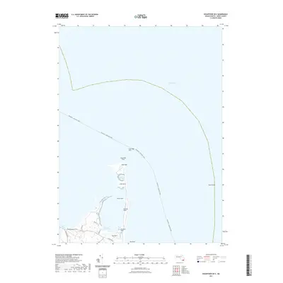
2021 Map of Edgartown OE E
USGS Topo · Published 2021About this map
Cape Poge and its surrounding coastal features dominate this northeastern portion of Chappaquiddick Island, capturing the intricate shoreline of Dukes County in the early 21st century. The map illustrates a landscape shaped by shifting sands and tidal waters, where points like Simon Point, Whistler Point, and Tom Neck Point define the eastern edge of the interior bay. Local transport is represented by the transit line of the Oak Bluffs - Nantucket Ferry crossing through the Main Channel, while on land, Chappaquiddick Rd and Dike Bridge Rd provide the primary access to this remote peninsula. The cartography highlights significant wetland environments, including the Cape Poge Bay Marshes and Caleb Pond Marshes, which separate the coastal ponds like Shear Pen Pond from the open Atlantic. This survey offers a detailed look at the island's coastal geography before further natural erosion or rising sea levels alter these fragile barrier beach formations.
Find a feature on this map
21 named features on this map. Tap any name to fly to it.
Don’t see what you’re looking for? This feature index may not catch every label — zoom into the map to look around manually.
Map Details
Editions of this 2021 Edgartown OE E Map
This is the sole edition of this map. No revisions or reprints were ever made.
Other maps of this area

1886 · Falmouth
USGS Topo · 1:62,500

1887 · Muskeget
USGS Topo · 1:62,500

1887 · Marthas Vineyard
USGS Topo · 1:62,500

1888 · Falmouth
USGS Topo · 1:62,500

1889 · Muskeget
USGS Topo · 1:62,500

1889 · Marthas Vineyard
USGS Topo · 1:62,500

1893 · Muskeget
USGS Topo · 1:62,500

1893 · Falmouth
USGS Topo · 1:62,500

1894 · Marthas Vineyard
USGS Topo · 1:62,500

1899 · Muskeget
USGS Topo · 1:62,500