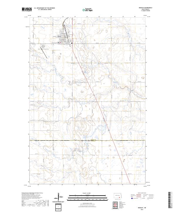
2024 Map of Edgeley
USGS Topo · Published 2024About this map
Edgeley sits at the intersection of prairie agriculture and protected wetlands in this modern survey of LaMoure County. The town's layout is defined by a grid of numbered streets and avenues, serving as a hub for the surrounding township sections. Local genealogy and history are anchored at the Mount Calvary Cem and Mount Hope Cem located on the eastern and western edges of the settlement. The landscape transitions from the urban center to the Edgeley Municipal Airport and out toward the Lamoure County Waterfowl Production Area, highlighting the region's commitment to conservation amidst active farmland. Waterways including the Maple River and Maple Creek thread through the terrain, illustrating the natural drainage patterns of the Dakota prairie. A network of rural roads, such as 80th Ave SE and Co Hwy 4, connects the scattered farmsteads across the township lines.
Find a feature on this map
32 named features on this map. Tap any name to fly to it.
Don’t see what you’re looking for? This feature index may not catch every label — zoom into the map to look around manually.
Map Details
Editions of this 2024 Edgeley Map
This is the sole edition of this map. No revisions or reprints were ever made.
Other maps of this area

1894 · Monango
USGS Topo · 1:62,500

1896 · Edgeley
USGS Topo · 1:125,000

1925 · Edgeley
USGS Topo · 1:125,000

1953 · Jamestown
USGS Topo · 1:250,000

1956 · Jamestown
USGS Topo · 1:250,000

1971 · Merricourt
USGS Topo · 1:24,000
1982 · Monango NW
USGS Topo · 1:24,000

1982 · Deisem
USGS Topo · 1:24,000
1982 · Kulm-Edgeley Dam
USGS Topo · 1:24,000
1982 · Monango
USGS Topo · 1:24,000