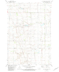
1982 Map of Kulm-Edgeley Dam
USGS Topo · Published 1983About this map
Glacial prairie landscapes across the border of La Moure and Dickey Counties define this rural North Dakota region in the late 1970s and early 1980s. The terrain is marked by a network of townships including Pomona View, Golden Glen, Ray, and Nora. Water management is central to the area's geography, evidenced by several reservoirs and earthen structures such as Schlecht-Thom Dam and the Kulm-Edgeley Dam, the latter of which features an adjacent Picnic Area for local recreation. Genealogists may find value in the location of Beresena Cem in the western portion of the map. The landscape also reflects local industry through several Gravel Pits and various wells, while the southeastern corner is occupied by the township of Potsdam.
Find a feature on this map
13 named features on this map. Tap any name to fly to it.
Don’t see what you’re looking for? This feature index may not catch every label — zoom into the map to look around manually.
Map Details
Editions of this 1982 Kulm-Edgeley Dam Map
This is the sole edition of this map. No revisions or reprints were ever made.
Other maps of this area

1894 · Monango
USGS Topo · 1:62,500

1896 · Edgeley
USGS Topo · 1:125,000

1925 · Edgeley
USGS Topo · 1:125,000

1953 · Jamestown
USGS Topo · 1:250,000

1956 · Jamestown
USGS Topo · 1:250,000

1971 · Merricourt
USGS Topo · 1:24,000

1971 · Merricourt NW
USGS Topo · 1:24,000
1982 · Monango NW
USGS Topo · 1:24,000

1982 · Schlecht-Weixel Dam
USGS Topo · 1:24,000

1982 · Deisem
USGS Topo · 1:24,000
Featured Places
- Potsdam Township, ND
- Golden Glen Township, ND
- Ray Township, ND
- Young Township, ND
- Pomona View Township, ND